Innisfil Historical Society
Pages
-
-
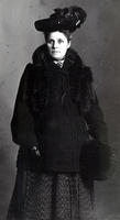
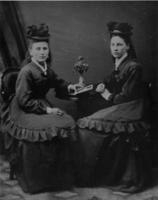
Maggie Johnston
-
Portrait of Maggie Johnson, sister of Mrs. Robert A. Sutherland of Stroud., IHS2310
-
-
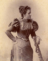
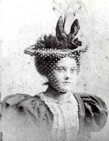
Maidie Barclay
-
Came with a picture of John Cowan (ID #15) in envelope with the following message: "To my Cousins John and Maidie. Wishing you the Compliments of the Season, 1899. From your Cousin Jessie. Down by the Sea."
Maidie Barclay (1868 - 1924) married John Cowan
- was only child of Francis Barclay and Agnes Nelson. Costumes and clothing., IHS1184
-
-
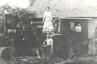
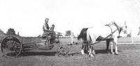
Maiel Family
-
Photo of Mary Maiel (née Summers) standing in a long sleeved white dress on a steam tractor that has been modified with a cab for passengers. Inside the cab are her daughters, Dorothy and Ilene. Standing in front of the machine is Sam Maiel in short sleeves and suspenders. The tractor has steel wheels and appears to be parked in front of a farmhouse., IHS3229
-
-
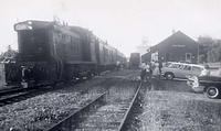
Mail Delivery At Cookstown Train Station
-
Photograph showing a crowd of people waiting beside their cars at the Cookstown train station for their mail delivery. The cars appear to date from the 1940s or 1950s. Two tracks are visible passing directly in front of the station, and the train itself is stopped on the track farthest from the station. The station was originally built sometime around 1877 when the Hamilton & North-Western Railway was built from Hamilton to Allandale. The building was later absorbed into a semi-detached residence located on Wellington Street. Two passenger trains passed through Cookstown twice daily six days a week: once at 10:20 a.m. northbound to Meaford via Allandale, and a southbound train stopping in Cookstown at 5:02 p.m. Freight trains stopped once daily for grain or coal. The station closed in April 1967 as rail service declined in popularity.
-
-
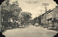
Main Street, Cookstown
-
View of Queen Street looking east from George Street in Cookstown circa 1920. The Village of Cookstown was named after Major Christopher Cooke's father, Thomas Cooke. The image depicts the road running down the centre with cars parked on either side with telephone poles along the right side of the road. The photo was likely taken during the summer.
-
-
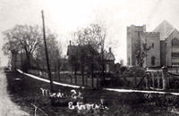
Main Street, Stroud
-
Photograph taken of the corner of Hwy. 11 and the 10th Line, now Victoria Street, in Stroud., IHS555
-
-
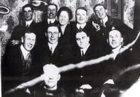
Male Chorus
-
Photograph of the male chorus from the Churchill Presbyterian Choir. Singers at Churchill sang at garden parties, church anniversaries, and other events. They were led by Walter Reive and accompanied by Mildred Todd. Pictured from left to right - Back Row: Marshall Reeve, Howard Allan, Mildred Todd, and Dr. Pichard
Second Row: Bob Duncan, O.E. Todd, Walter Reive, and Dwight Rogerson. Front Row: Joe Duncan., IHS152
-
-
Maneer, Samuel
-
Obituary of Samuel Maneer of Craigvale which appeared in the Barrie Examiner on July 19, 1923. He died July 14, 1923.
Further information is available at the Knock Heritage Site, IHS3556
-
-
Manure Spreader
-
Bruce Wice and sons, Ross and Mervin, are pictured here using a manure spreader pulled by two horses., IHS3870
-
-
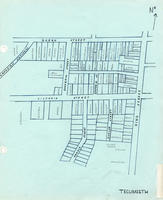
Map Of Cookstown - Tecumseth Section
-
Hand drawn map of the part of Cookstown that was formerly a part of Tecumseth Township. It is the southwest quadrant of the town, limited by Queen Street across the top and and King Street across the side and includes Dufferin St., Donald St., Evelyn St., Empress St., Victoria St. West and Selby St. [unlabelled]. The map shows a Bell Telephone office located on Dufferin St. indicating that it was drawn sometime after 1959.
-
-
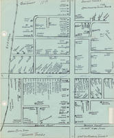
Map Of Cookstown 1897
-
Hand-drawn map of Cookstown from 1897 featuring the location of the households and businesses of the community.
-
-
Map Of Haughton Sawmill
-
Hand drawn map of the Haughton sawmill including the shingle mill, millpond, dam, house, stable, and creek. The creek was the chief feeder to the Nottawasaga River.
-
-
Map Of Innisfil, 1923
-
Map of Innisfil - 1923. An advertising poster on farm products. Note: BARCLAY - should be on corner of 8th conc, not on 7th as shown. It was the 7th conc. that was unopened, not the 8th as shown., IHS464
-

-
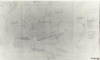
Map To Lloyd George Park
-
(B) Map showing entrance in relationship to CNR
Further information is available at the Knock Heritage Site, IHS3905B
-
-
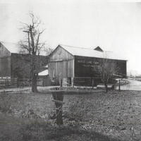
Maple Lane Farms
-
Image of Roy and Clara Goodfellow's Barns taken in 1954. Their farm is known as Maple Lane Farm. The image shows two barns, one with writing on the side that says "Maple Lane Farm". Wooden fences and one tall tree can also be seen in the image.
This farm was located at Lot NH 23, Concession 8., IHS3937
-
-
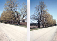
Maple Trees 10Th Line Of Innisfil
-
Maple trees, which according to family tradition were planted by William Edwin Pearson bordering the 10th line of Innisfil and east of the farmhouse located at S 1/2 of Lot 2, Concession 10, when he was 18 years of age. William was born circa 1866 and therefore these maples would have been planted circa 1884.
These trees would therefore, at the time this photo was taken have been approximately 118 years old.
During the 1940's I recall my parents and I tapping these trees to make Maple Syrup for our own use. the Field and the road along which these trees stretched would flood during the Spring melt, so often we would have to put on our rubber boots and wade through the water in order to collect the sap.
This photo was taken by Raymond Crane, grandson of William., IHS4085C
-
-
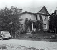
Mapleton House
-
Photo of the house known as "Mapleton" in Holly. It was built c.1908 and served as the home of Clarence Srigley and his family., IHS2696
-
-
Margaret And Beattie Mcconkey
-
(l to r) Twins: Margaret and Beattie McConkey. Beattie married Rod McConkey --their family: Blythe, Addie (Black) Bert, IHS1291s
-
-
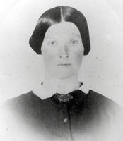
Margaret Ann Mcdougall
-
Portrait of Mrs. Margaret Ann Gregg (née McDougall, wife of George Gregg) who lived in Belle Ewart circa 1914., IHS262 s
-
-
Margaret Black
-
Portrait of Margaret Black (née Booth), grandmother of Robert Herbert Black and wife of Robert Black Sr. who was the son of James Black, an Innisfil pioneer. She lived with her husband and their five children on the northwest corner of lot 10 on the 20th sideroad of Innisfil. The property remained in the Black family for over 100 years. In this photo Margaret is wearing a collared blouse or dress and her hair held back in a style common in the mid-to-late nineteenth century., IHS829
-
-
Margaret Boyes
-
Photo of Margaret Hannah Boyes, wife of John Boyes Sr. and mother of Robert Boyes, Thomas Boyes, and John Boyes II., IHS2664
-
-
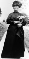
Margaret Boyes
-
Photo of Margaret Hannah Boyes on a sidewalk in Churchill. She was born on 26 August 1848 and died on 25 September 1920. She was married to John Boyes Sr. and together they had three children: Robert, Thomas, and John., IHS2663
Pages